
An Analysis of Tropical Cyclone Alfred
- Weatherwatch
- Mar 16
- 23 min read
March 16, 2025

A rare view of the eye of a tropical cyclone on Brisbane radar. Source: Weatherwatch HailTracker GIS Platform.
Tropical Cyclone Alfred was a defining moment for Southeast Queensland, finally putting to rest the myth that cyclones cannot directly impact the region. While often seen as a rare occurrence, history tells a different story—on average, a cyclone crosses the coastline every 20 years. The last official landfall was Tropical Cyclone Zoe in 1974, though Nancy in 1990 came close. The most powerful known cyclone to impact the area remains the 1954 Gold Coast Cyclone, an estimated Category 3 system that caused widespread damage.
But Alfred was more than just a reminder of the region’s vulnerability—it was an opportunity to analyse the anatomy of a southern tropical cyclone and better understand how past systems may have survived in these waters. In this deep dive, we’ll break down what made Alfred unique, explore why ex-Tropical Cyclone Alfred felt more intense than when it was a named system, look at historical trends, and assess whether Southeast Queensland is in another active period for extreme weather. Finally, we’ll reflect on key lessons learned from one of the most significant windstorms to hit a major Queensland population in recent history.
Loop of Alfred approaching Southeast Queensland. Source: Weatherwatch HailTracker GIS Platform.
Contents
Was Alfred a True Tropical Cyclone?
One of the biggest debates in meteorology was whether Alfred was a "true" tropical cyclone. As with many meteorological definitions, grey areas exist, and Alfred sat right in the middle of one. The Bureau of Meteorology (BoM), which oversees tropical cyclone classification in Australia, defines a tropical cyclone as:
In the Australian region, a tropical cyclone is defined as:
a warm-cored, non-frontal low pressure system of synoptic scale developing over warm waters
having organised convection and
a (10-minute mean) wind speed of at least 34 knots or 63 km/h, extending more than halfway around near the centre and persisting for at least 6 hours.
While wind speed is a clear-cut criterion, the "warm core" aspect is more subjective. To understand whether Alfred met this definition, let’s break it down step by step in reverse order.
A (10-minute mean) wind speed of at least 34 knots or 63 km/h, extending more than halfway around near the centre and persisting for at least 6 hours.
Wind speed is one of the easiest parameters to verify. Satellite wind analysis (RADARSAT scans) showed that Alfred consistently maintained winds above 34 knots, meeting this requirement. Interestingly, past ex-tropical cyclones like Oswald (2013) and Debbie (2017) failed this test, despite Oswald producing similar wind impacts to Alfred.


RADARSAT wind analysis. While Alfred was a far more intense tropical cyclone in the northern Coral Sea, Alfred still met the wind criteria for a tropical cyclone in the southern Coral Sea. Source NOAA
Having organised convection
Organised convection, another key factor, requires a structured circulation, which Alfred clearly displayed on both satellite and radar imagery.

A warm-cored, non-frontal low pressure system of synoptic scale developing over warm waters
Alfred was non-frontal synoptic scale low pressure system. Further, Alfred developed in the northern Coral Sea where ocean temperatures (29-30C) well exceeded that for tropical cyclone formation (>26.5C).
The warm-core aspect is where things get tricky. A tropical cyclone is typically barotropic, meaning it derives energy purely from ocean heat, unlike East Coast Lows, which gain energy from upper-atmosphere interactions (baroclinic systems). Alfred was warm-cored for much of its lifetime, but as it moved into the southern Coral Sea, it began showing subtropical characteristics with a question as to whether it was a "true" tropical cyclone.
This raises an important question: at what point does a tropical cyclone stop being warm-cored? Does it have to be 100% warm-cored? What about 80% or 50%? A warm-cored system is defined that the temperature at its centre is warmer than that of the air around it, including in the upper atmosphere. Further, the structure extends vertically (and doesn't 'lean').
A useful analogy: if dough is placed in the oven, at what point does it become bread? Most would agree that bread can still be slightly undercooked and still be classified as bread. Similarly, a tropical cyclone may begin transitioning, but it doesn’t immediately stop being a tropical cyclone. In other words, there is a transition phase.
Did Alfred Transition to a Subtropical System?
Alfred’s upper-atmosphere temperature structure provides insight into whether it remained a tropical cyclone. Early in its life, it was clear that Alfred was completely barotropic, though in the southern Coral Sea we can see Alfred (while retaining a warm pool in the upper atmosphere), is very close to the upper trough (and was in fact, interacting with and gaining energy from this upper trough).


Early stages of Alfred saw no interaction with cold air in the upper atmosphere but later in its lifecycle contained interaction with an upper trough (300mb temperatures from February 18 and March 7, 2025). Source: Weatherwatch MetCentre.
The question then arises, was Alfred sufficiently warm cored to be considered a tropical cyclone? Satellite imagery in the latter part of Alfred's lifetime certainly exhibited sub-tropical structure with the system. Early in Alfred's lifetime, examining the 700, 500, 300 and 200mb temperatures clearly shows warm air at all of these levels - and when we plot them, we can see the spread is just 56km, that is the difference between the 700mb and 300mb warm pools were offset by a distance of 56km.
When Alfred was located off Brisbane, there were very defined 700mb, 500mb warm pools and a somewhat defined 300mb warm pool in the upper atmosphere above the cyclone, however there was no overly evident 200mb warm pool. This is not surprising given when Alfred tracked into the southern Coral Sea, it eventually began to sit south of the sub-tropical jet which was most defined at 200mb.


Comparison between 700-500-300-200mb temperatures . Alfred's warm pools in the upper atmosphere were more pronounced in the northern Coral Sea, and while still present in the southern Coral Sea were less pronounced. Source: Weatherwatch MetCentre.
It appears that Alfred contained a warm core between the surface to 300mb (or about 0m to 10,000m in height), but lacked a warm core between 10,000m and 12,500m.
Tropical cyclone phase models provide further insight. assisting in classifying systems according to their temperature, symmetry and depth:
Phase Plot One | Phase Plot Two |
|
|
|
|
|
|
|
|
Across all models, Alfred was classified as a deep, symmetric warm-core system for most of its life. As it moved south, it temporarily became a shallow, asymmetric warm-core system, but upon approach to southern Queensland, it regained deep, symmetric warm-core characteristics.


UKMET Tropical Cyclone Phase Plots showing that Alfred briefly transitioned to a sub-tropical system before becoming 'more tropical' prior to landfall. Source: Florida State University.
Was Alfred a True Tropical Cyclone?
While the argument to consider Alfred a sub-tropical cyclone exists, the overall structure and wind field remained more aligned with a true tropical cyclone rather than a hybrid system. Subtropical systems tend to share features with East Coast Lows, but Alfred displayed little resemblance to an East Coast Low and behaved much more like a fully tropical cyclone.
In summary, while Alfred was 'less' tropical off the southern Queensland coastline than over the northern Coral Sea, it seems that it was 'tropical enough' to be considered a tropical cyclone (particularly prior to landfall). Had Alfred officially been classified something other than a tropical cyclone during its sub-tropical phase, it would have resulted in a great deal of confusion to the public. This was particularly demonstrated around some of the misconceptions that an ex-tropical cyclone is no longer dangerous (as discussed later).

Tropical Cyclone Alfred had a very large eye offshore. Source: Weatherwatch HailTracker GIS Platform.
How Did Alfred Get So Far South?
Contrary to popular belief, tropical cyclones semi-frequently drift down as far south as the Queensland/NSW border. Ocean temperatures even in the southern Coral Sea are supportive for category 1 or 2 tropical cyclones and at times, supportive of category 3 and occasionally even category 4 systems. The real question is why did a tropical cyclone so far south move towards the coastline when most tropical cyclones at this latitude tend to move away.

Under normal circumstances, southern Queensland is protected by steering winds that push cyclones eastward, away from the coast. These west-to-east winds—the same ones that drive thunderstorms from the ranges toward the coastline—typically act as a natural barrier for tropical systems. However, these winds aren’t always westerly, particularly between January and early March, when wind patterns can shift, allowing rare southern cyclones to approach the coast. During January and the first half of February, the steering flow in the Coral Sea remained strongly westerly - ensuring any potential tropical lows were pushed further away into the Pacific Ocean.

Why Did Alfred Eventually Track West?
Alfred developed on February 23, but its origins trace back several days earlier, when a low formed off Cairns. At first, a strong jet stream across the Coral Sea helped steer the system eastward, keeping it away from Queensland. Initially, the low remained disorganised, but as wind shear decreased, it consolidated into a tropical cyclone.
One of the defining characteristics of Alfred’s movement was its slower-than-expected forward speed. Multiple passing upper troughs could have captured Alfred earlier and pulled it southeastward, but the cyclone repeatedly missed these interactions—allowing it to maintain a slow, steady southward track. This trend continued as Alfred marched through the Coral Sea, peaking at a high-end Category 3 or low-end Category 4.

Meanwhile, a mid-to-upper level ridge developed over eastern Australia, extending into the Tasman Sea. Just as surface troughs and ridges shape winds at the ground level, these upper-level systems influence wind flow higher in the atmosphere. As the ridge built, it gave Alfred a small westward nudge, shifting its path toward Queensland on March 1–2, 2025.

A new upper trough then moved in from the west on March 3, steering Alfred back toward the southeast.

At this point, Alfred began interacting with cooler air from the approaching upper trough, causing it to lose some of its purely tropical characteristics. Normally, tropical cyclones in this environment struggle due to increased wind shear, which disrupts their core structure. However, Alfred underwent a partial subtropical transition, allowing it to draw some energy from the upper atmosphere rather than relying entirely on ocean heat.
As Alfred neared southern Queensland, the ocean remained warm enough to sustain a tropical cyclone. This allowed Alfred to revert to a more tropical structure, despite its earlier transition phase.
Once again, a mid-level ridge redeveloped over eastern Australia and the Tasman Sea, shifting the steering winds and helping Alfred turn back toward the coastline. At this stage, Alfred was expected to accelerate toward land, but instead, model guidance began suggesting a slower and more erratic movement.

Alfred's Erratic Movement & Landfall
Alfred’s slower movement was likely caused by two competing steering influences:
A mid-level ridge over NSW and the Tasman Sea, influencing lower atmospheric flow
A mid-level ridge over the northern Coral Sea, driving upper atmospheric flow

Since Alfred was not an overly tall system, the Tasman ridge ultimately had the stronger influence, leading to a slow, westward drift toward the coast.
Alfred finally crossed the Moreton Bay islands on the evening of March 7 as a high-end Category 1 / low-end Category 2 cyclone before weakening over land as an ex-tropical cyclone on March 8.
For residents of Southeast Queensland, one important distinction must be made:
The outer eyewall grazed the Gold Coast and Brisbane’s bayside, but the actual eye never crossed the mainland.
Had the main eye crossed over the mainland land, the impacts would have been far more severe.
Alfred ultimately weakened just before landfall, likely due to interactions with islands and higher terrain. Since tropical cyclones rely on ocean heat for energy, even minor land interactions can cause them to lose strength. This explains why Alfred was pushed northward, finally crossing near Bribie Island late on March 9 as a decaying system.
Had Alfred been a more intense system on approach to the coastline (as initially forecast), Alfred's weakening may have been insufficient for it to be steered northwards from the ridge to the south. This potentially explains the sudden shift in the slow-down and more erratic forecast movement prior to landfall and identifies the nuances in weather forecasting where a seemingly minor change can lead to a greatly different outcome.
Forecast Analysis
Weatherwatch provides tropical cyclone forecasts to a broad range of organisations, including insurers, government agencies (Local Disaster Management Groups), electricity networks, and transport and logistics companies across Australia.
Below are some quotes from our weather forecast discussions on Alfred leading up to Alfred's movement into the southern Coral Sea: (Skip to Overview)
February 20
"...In the short to medium term, conditions are not supportive for this system (or any other lows in the Coral Sea) to track towards the Queensland coastline thanks to a series of cold fronts tracking across southeastern Australia that will keep any system from drifting closer to the coastline. In the long-term, wind shear patterns may shift towards the end of the month with the jetstream weakening and this may remove this blocking mechanism. This does not mean the system would track back towards the coastline, only that conditions blocking systems from tracking towards the Queensland coastline will be removed and thus long-term patterns will be monitored."
This pattern was monitored closely with daily updates:
February 22
The system will continue to be monitored - unlike previous lows, the confidence of this system remaining offshore is lower with a wide range of potential scenarios
February 24
Forecast guidance remains split between two scenarios: 1. A passing upper trough through southeastern Australia will capture the system, and carry it eastwards, away from the Queensland coastline. 2. Alfred may move too slowly to interact with this upper trough meaning the upper trough will clear before Alfred arrives. A new mid to upper ridge will establish itself across eastern Australia resulting in a more easterly wind pattern through the mid-levels of the atmosphere. Such a scenario may steer Alfred towards the Queensland coastline.
On the 28th of February, Weatherwatch began to escalate its concern that the system could approach the southern Queensland coastline:
"There is growing confidence that Alfred may become slow moving off the southern Queensland coastline by mid next week. While the obvious impacts are that Alfred would maintain strong winds and large swells to the southern Queensland coastline for longer, there is the concern that Alfred could begin to lose its tropical characteristics and become sub-tropical (or a hybrid system). A sub-tropical system would behave and move differently to a tropical system. A tropical system would become weakened by an approaching upper trough or, steered away from the coastline. A sub-tropical system however could actually track towards the upper trough which would draw the system closer to the coastline later next week and this will be closely monitored. In other words, if Alfred stalls off the southern Queensland coastline and becomes more sub-tropical than tropical, the chance that Alfred could eventually move back towards the southern Queensland coastline and bring more adverse weather conditions is higher."
March 1
We formally acknowledged the potential for Alfred to cross the southern Queensland coastline:
Alfred is expected to swing back to the southeast tomorrow and remain offshore for the next few days as the upper trough pushes Alfred away (this will still generate dangerous surf and gales along the southern Queensland coastline). However, Alfred may lose some of its tropical characteristics next week. This process (sub-tropical transition) would result in Alfred moving differently and could begin to interact with the upper trough and track westwards (as opposed to moving away from the upper trough). This would be enhanced by a small mid-level ridge to the south helping to once again provide another easterly steering flow. Such a path would see Alfred track closer to the southern Queensland coastline later next week opening up a series of more concerning scenarios that would generate a higher potential for heavy rainfall and damaging wind gusts to areas of the southern Queensland coastline. Some of these scenarios include a potential crossing of the system.
March 2
Alfred is expected to track more southeast today and weaken as the system comes under the steering influence and wind shear of the upper trough. Beyond this, Alfred's interaction with the environment become highly complex (see below for detailed explanation). However there is increasing confidence that Alfred will shift back to the west with a reasonable potential for landfall along the NE NSW or SE QLD coastline. Whether Alfred is a weak tropical cyclone of an ex-tropical cyclone, the impacts are unlikely to change - with extensive gales, damaging winds and torrential rainfall favoured (particularly to the south of the centre).
By March 2, forecast confidence had significantly increased, with all models aligning on a direct impact to Southeast Queensland and northeastern New South Wales. While earlier forecasts had shown uncertainty, by this stage, every major forecast model supported a landfall in the region, varying only by 200–300 km and within a 24-hour window.
From March 3 to 4, model guidance remained remarkably consistent, reinforcing confidence in Alfred’s path. However, by the afternoon of March 5, all forecasts abruptly shifted, indicating a sudden slowdown toward the coastline.

The Complexity of Tropical Cyclone Forecasting
Forecasting tropical cyclones is inherently complex, and in recent years, there has been a growing reliance on model guidance. While weather models have improved, they still struggle with the intricate nature of atmospheric patterns, particularly in regions like the Coral Sea. This is where experienced meteorologists play a critical role, providing a guiding hand to interpret model data, recognise historical patterns, and identify potential inaccuracies.
Alfred was a particularly challenging system to forecast because there were no recent comparable cyclones. In fact, only one other system—Cyclone Nancy in 1990—has ever been captured on Brisbane radar, leaving very little historical data for reference. As a result, Alfred’s movement remained unpredictable, slowing down, completing multiple loops, before finally making landfall as an ex-tropical cyclone on March 8.
Some of the reasons for Alfred’s erratic behaviour are discussed here, but tropical cyclone forecasting in the Coral Sea is notoriously difficult. This region experiences highly variable steering patterns that can change daily, often leading to systems that suddenly shift direction, stall, or complete loops. This results in a wide range of potential scenarios, making long-range forecasts especially unreliable.
One of the other changes that occurred was the forecast positioing of rainfall with rainfall initially expected to favour areas south of Brisbane. However Alfred's shift further northwards resulted in some of the heaviest falls occurring around the Brisbane metropolitan area and Brisbane recorded 275mm to 9am on Monday the 10th of March making it the wettest day in the CBD since the 1974 floods (noting that higher falls occurred in 2022 outside of the CBD).


Initial forecasts had the heaviest rainfall occur south of the CBD but eventually this shifted to not only occur over the Brisbane metro region but into the Ipswich and Lockyer Valley areas. Source: Weatherwatch MetCentre.
Why Forecast Models Alone Can’t Be Trusted
An example of this unpredictability occurred in January, when forecast models initially suggested a monsoon trough and tropical low would form into a cyclone and impact Southeast Queensland. Instead, the system never developed into a cyclone, and its heaviest rain fell over 1,500 km north, between Townsville and Cairns.

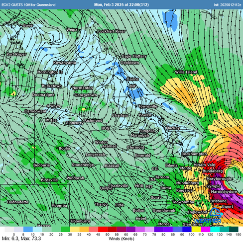


Two forecasts for February 3, 2025. The first was +312 hours and the second was +36 hours. Often extreme forecasts beyond 168 hours do not eventuate. Source: Weatherwatch MetCentre.
Alfred posed a similar forecasting challenge, with some models predicting a southern Queensland landfall, while others showed a track toward Mackay, New Caledonia, or even New Zealand.

At Weatherwatch, our meteorologists go beyond model predictions, assessing broader atmospheric patterns to provide more accurate and informed cyclone forecasts. Rather than relying solely on automated guidance, our team applies decades of experience to interpret the subtleties of each system—because in cyclone forecasting, experience and pattern recognition can mean the difference between uncertainty and clarity. This was particularly useful in understanding the impacts Alfred would have after it crossed the coastline and became an ex-tropical cyclone as this is something the region has experienced several times over the past 15 years. This resulted in a higher level of confidence for the potential for significant flash flooding under a convergence line after Alfred crossed (even before models had forecast this to occur).

The Impacts of Alfred & Why Ex-Tropical Cyclone Alfred Felt More Severe To Some
Tropical Cyclone Alfred was far from a textbook system—its slow movement, erratic track, and unexpected strengthening offshore led to widespread impacts. Early concerns of a mid-to-high Category 2 landfall fortunately did not eventuate. Instead, Alfred’s outer eyewall grazed the Gold Coast, producing 107 km/h wind gusts at the Gold Coast Seaway and 100 km/h at Coolangatta. Byron Bay recorded 120 km/h, though this is an exposed coastal location. A private weather station at Beechmont in the Gold Coast Hinterland recorded 141 km/h, but due to its elevated location, this was likely topographically enhanced.
Top Wind Gusts:
141km/h Beechmont (unofficial station & topographically influenced)
120km/h Byron Bay (topographically influenced)
107km/h Gold Coast Seaway
104km/h Redcliffe
100km/h Coolangatta
98km/h Toowoomba AP
93km/h Brisbane AP
As Alfred approached the coastline, it began to weaken due to land interaction—particularly as it encountered higher terrain. This caused a shift in movement northward as a weaker system allowed the ridge to the south to have a stronger steering influence and resulted in the category 1 strength winds extending into areas of Moreton Bay and Brisbane bayside. By 6 AM on March 8, 2025, Alfred was officially reclassified as an ex-tropical cyclone.
The Misconception Around Ex-Tropical Cyclones
One of the biggest misunderstandings in meteorology is the assumption that when a system is reclassified as an ex-tropical cyclone, it has weakened significantly. At Weatherwatch, we avoid using terms like "downgrade" because in many cases, an ex-tropical cyclone can still be as intense as, a tropical cyclone—it's just a technical difference.
A tropical cyclone is officially defined as a system with 10-minute sustained, gale-force winds (≥63 km/h) extending more than halfway around the centre. In some cases, the system can 'weaken' and gale-force winds will cover less than 50% of the system. Once this occurs it is classified as an ex-tropical cyclone, even if it still produces damaging winds.
This was the case with Ex-Tropical Cyclone Alfred Alfred. While it no longer met the technical definition of a tropical cyclone, it still contained Category 1-strength winds in its southeastern quadrant. This was evident at Redcliffe, which recorded sustained winds of 82 km/h (high-end Category 1) and gusts of 104 km/h on March 8—borderline Category 2 strength. Further, when Alfred was off the coastline, winds were quite southerly meaning that large areas of Southeast Queensland were sheltered. However once Alfred tracked inland, winds swung to the east providing a more direct line of winds.

Ex-Tropical Cyclone Alfred essentially became a system very similar to that of Oswald and Debbie in 2013 and 2017 respectively - with Oswald being a very similar system by the time Ex-Tropical Cyclone Alfred crossed the coastline.


Previous systems such as Ex-Tropical Cyclone Oswald and Ex-Tropical Cyclone Debbie also produced pockets of category 1 strength winds (particularly Oswald).
One way to measure the severity of wind impacts is through power outages. Initial estimates from Energex suggest that around 500,000 properties lost power during Alfred—making it the largest outage event in Southeast Queensland history from a wind event.
For comparison:
Ex-TC Oswald (2013): >295,000 outages
Gold Coast Derecho (2023): >110,000 outages
Despite the eye never directly crossing Brisbane, many residents were caught off guard when ex-Tropical Cyclone Alfred moved inland and brought widespread Category 1-equivalent winds to the city’s suburbs.
Similarly, (and fortunately), as Alfred approached from the east, winds were southerly for much of the pre-event rainfall. This resulted in fairly light rain falling across the catchments (apart from the Border Ranges and Gold Coast hinterland, and over northeastern NSW). Unlike Oswald that tracked down from the north, which resulted in days of onshore E to NE winds that saturated the catchments prior to its arrival.

However, as Alfred crossed the coastline it generated an intense band of convergence that also tracked over the region. This area of converging winds in a humid environment helps support very heavy rainfall. While in normal convective environments, heavy shower and storm activity over a single location can cause situations to weaken, in the case of convergence zones there is a quasi-balanced state of continual warm, humid air flowing into a region. The converging winds then cause the humid air to rise and condense into heavy rainfall.
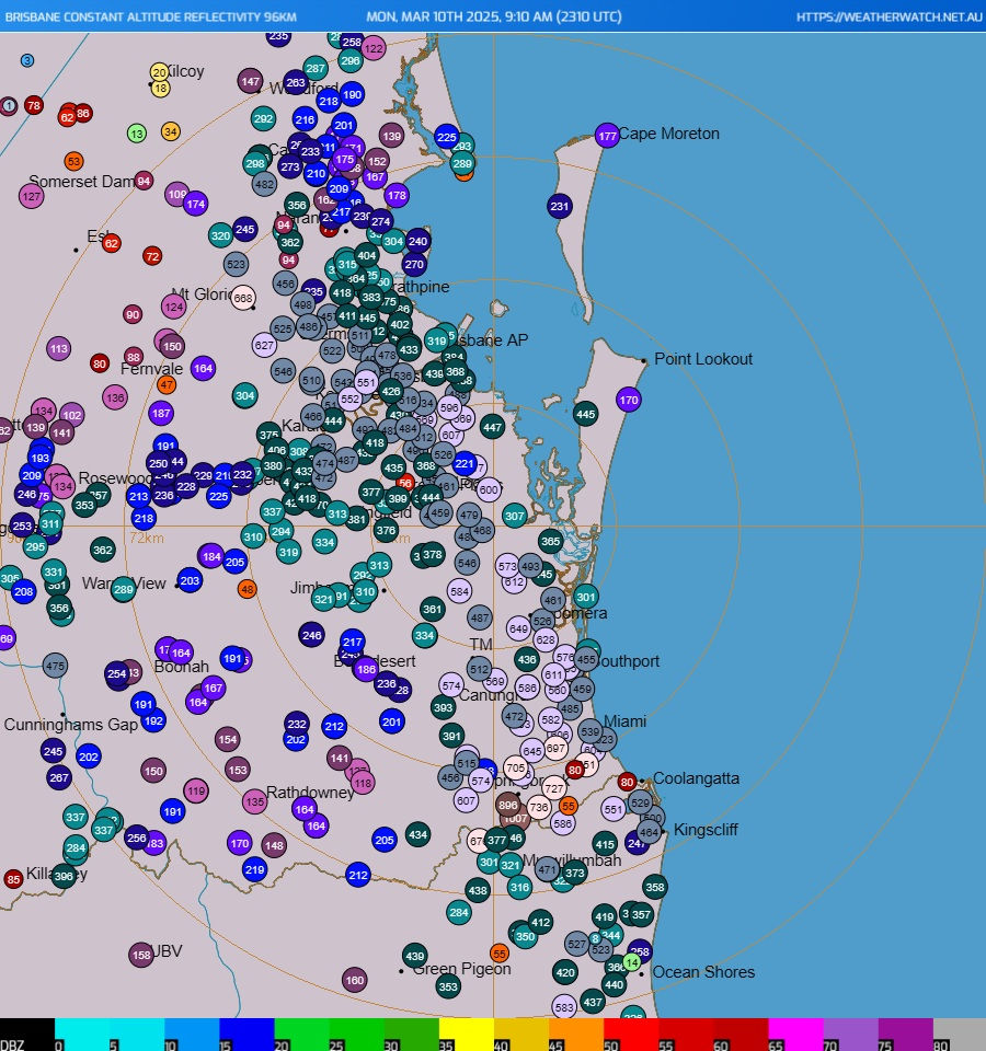

Post-cyclone convergence zones are common, similar patterns occurred during Jasper (2023) in Cairns, and Oswald (2013) as it tracked down the coastline. These convergence zones can be more pronounced when the low is located near the coastline. Due to friction, air can rush in faster over the ocean compared to land which can cause even more uplift along the point of convergence.

Convergence zone generating intense rainfall across Southeast Queensland on Sunday morning the 9th March. Source: Weatherwatch HailTracker GIS Platform.
Highest Rainfall Totals (March 1 - 15):
Location (Highest) | Amount | Location (Notable) | Amount |
Springbrook | 1116mm | Burleigh Heads | 613mm |
Lower Springbrook | 1082mm | Coolangatta | 580mm |
Coolawarrah | 756mm | Mt Gravatt | 502mm |
Binna Burra | 748mm | Gold Coast Seaway | 475mm |
Lowanna | 747mm | Brisbane | 474mm |
O'Reillys | 739mm | Nambour | 473mm |
Tweed Heads | 715mm | Archerfield | 468mm |
Mt Tamborine | 675mm | Lismore | 407mm |
Numinbah | 658mm | Grafton | 405mm |
Point Lookout | 654mm | Hervey Bay | 354mm |
However with the impacts of Tropical Cyclone Alfred are still being assessed, it'll likely be some time until a qualitative assessment can be made. As of March 14, 2025 the ICA (Insurance Council of Australia) has more than 53,000 claims on record. This value will climb as more claims come in. For comparison, Tropical Cyclone Jasper had 10,400 claims while the 2022 floods (one of the most expensive natural disasters in Australia's history) had 246,000 claims.
A History of Tropical Cyclones in Southeast Queensland - Previous Comparable Events
Southeast Queensland has a long history of tropical cyclones, though records before the 1950s are incomplete due to the absence of satellite imagery and limited observational data. Despite this, meteorologist Jeff Callaghan (Bureau of Meteorology, 1965–2008) conducted extensive research on Queensland cyclones. His analysis found that between 1883 and 1898, at least 24 intense tropical cyclones and extra-tropical cyclones impacted the southern Queensland and northern New South Wales coasts, resulting in over 200 fatalities in what was then a sparsely populated region (Callaghan, 2020).
A series of notable systems for the Southeast Coast region included:

One of the most extreme periods of cyclone activity occurred in 1893, when four tropical cyclones made landfall along the central and southern Queensland coast in a single season.
Among the most significant systems in recorded history:
1954 Gold Coast Cyclone – A Category 3 landfall near the Gold Coast, widely regarded as one of the most destructive cyclones to impact the region.
Tropical Cyclone Dinah (1967) – The closest a Category 4 system has come to Southeast Queensland, remaining at Category 4 strength off the coast, even at Brisbane’s latitude. Dinah caused significant storm surge damage and had a minimum central pressure of 945 hPa over Fraser Island.


1954 Gold Coast Cyclone (Category 3) and Tropical Cyclone Dinah (Category 4) in 1967. Source: ABC & Australian Severe Weather respectively.
Some pre-1900 cyclones may not have been true tropical cyclones but rather deep lows or ex-tropical systems. However, all documented events listed below had pressures below 995 hPa over the mainland, indicating they were still significant storm systems.
The 1892 system is particularly notable, as it occurred late in the season (late March–early April) yet caused extensive wind damage.
How Does Alfred Compare?
Given the limited historical data, direct comparisons between pre-1954 and modern cyclones remain challenging. However, based on intensity and impact, Alfred’s strength was similar to that of Ex-Tropical Cyclone Oswald in 2013 and possibly the most intense system to affect the Gold Coast since 1954.
Historically, the 1954 Gold Coast Cyclone remains the most significant landfalling system for the region. While no known Category 4 system has ever made landfall in Southeast Queensland, Cyclone Dinah’s offshore survival suggests that under the right conditions, a Category 4 system could reach as far south as the QLD/NSW border.
Between 1974 and 2011, there were very few significant flood events and cyclones, then between 2011 and 2025 there has been two major flood events, two ex-tropical cyclones and a tropical cyclone. What's causing this?
Are We in Another Active Period for Southeast Queensland?
Between 1974 and 2011, Southeast Queensland saw relatively few significant flood events or tropical cyclones. But since 2011, the region has experienced two major flood events, two ex-tropical cyclones, and now Tropical Cyclone Alfred—raising the question: are we entering another period of heightened cyclone and flood activity?
Historical records suggest that Southeast Queensland experiences clusters of extreme weather events, where cyclones and floods become more frequent for 20–25 years before easing off. Meteorologist Jeff Callaghan (Bureau of Meteorology, 1965–2008) conducted extensive research into Queensland’s cyclones and flood cycles. He was one of the first to suggest that rainfall and cyclone activity in the region may follow a cyclical pattern.

The Role of the Pacific Decadal Oscillation (PDO)
Anecdotal evidence has supported that tropical cyclones (and major flood events), are more likely to occur during a negative PDO (Pacific Decadal Oscillation) cycle.
The Pacific Decadal Oscillation (PDO) is a long-term climate pattern in the Pacific Ocean that shifts between warm and cool phases over decades (typically 20-30 years). It affects ocean temperatures, weather patterns, and climate across the Pacific region, including Australia.
There are two main phases:
Positive PDO (Warm Phase): Warmer-than-normal waters in the eastern Pacific and cooler waters in the western Pacific.
Negative PDO (Cool Phase): Cooler-than-normal waters in the eastern Pacific and warmer waters in the western Pacific.
A negative PDO is particularly important for Australia’s weather and climate because it strengthens La Niña-like conditions such as:
More Rain & Flooding Risk – Warmer waters near Australia fuel more cloud and rainfall, especially in the north and east.
Stronger La Niña Events – When combined with La Niña, a negative PDO amplifies wet conditions, leading to an increased risk of flooding and cyclones.
Stronger Trade Winds & Cyclones – More warm water near Australia means more fuel for tropical cyclones in northern Australia.
PDO Trends vs. Cyclone and Flood Activity in SE QLD
When PDO phases are plotted against Southeast Queensland’s cyclone and flood history, a clear pattern emerges:
Of the 20 significant cyclone events analyzed, 16 (80%) occurred during a negative PDO phase.
The average PDO value during these events was -0.76.
Despite the current negative PDO, the overall number of tropical cyclones in Australia has declined, adding complexity to the trend.

What Does This Mean for the Future?
While correlation does not imply causation, the links between negative PDO phases and increased cyclone/flood activity in Southeast Queensland are difficult to ignore.
Notably, we are currently in a strong negative PDO phase, with October 2024 recording the lowest PDO value on record at -3.8.
If past trends hold, it would be premature to assume that Southeast Queensland has seen the last of its major weather events. History suggests these events often cluster together for 20–25 years, and since the current negative PDO cycle began around 2008, there is a strong possibility that another decade of heightened cyclone and flood risk lies ahead before conditions shift back toward a positive cycle.

Lessons Learnt & Conclusion
Undoubtedly, there will be many lessons learned across industries from Tropical Cyclone Alfred. This was the first time in Australia’s history that such a large population was directly in the path of a tropical cyclone, creating an unprecedented level of concern over potential outcomes. Southeast Queensland was fortunate that Alfred weakened on approach, but had earlier forecasts of a mid to high-range Category 2 impact been realised, the situation could have been far worse.
At Weatherwatch, meteorology and science are at the core of our DNA. Examining this event from a meteorological perspective, several key takeaways emerged:
Model guidance often underestimates the duration of convergence zone rainfall. Events like this tend to start later and persist longer than expected, a pattern seen in previous systems, this appears to be a repeated pattern (ie Jasper, 2011 & 2022 flood events).
AI models struggled with Alfred. At times when every single traditional (NWP) model had Alfred crossing the coastline, AI models did not have this. One of the limitations of AI models is that they can only forecast what has happened before. While this type of learning is undoubtedly useful, it illustrates the critical importance of traditional modelling - as they can forecast events that have not happened before. Even a few days out, some AI models were forecasting a "light shower" in Brisbane on Sunday when suburbs had more than 300mm in a few hours.
Terrain interaction plays a critical role in cyclone weakening. Alfred weakened as it approached the islands and hinterland, but a faster-moving system may retain more strength before landfall. While the sample size in small, this suggests a bigger concern may be from a faster moving system allowing for less time to weaken.
The southern Queensland coastline is capable of sustaining & potentially intensifying tropical cyclones. Under the right conditions, warm ocean temperatures may not only support tropical cyclones but allow intensification—a possibility that may become more likely due to long-term Coral Sea warming trends.
Weather understanding is just as important as the forecast. At Weatherwatch, we aim to provide more than just predictions—we help people and businesses understand the weather. The overwhelming response to our updates reinforced how critical clear, contextual explanations are in reducing uncertainty and helping communities make informed decisions.

While not as frequent as in northern Queensland, tropical cyclones have always been a part of Southeast Queensland’s history—and always will be. Alfred was a stark reminder of the region’s vulnerability. This time, the area was spared the worst, grazed by the outer eyewall rather than enduring a direct hit. As the cleanup and recovery efforts continue, it’s also an opportunity to plan for the next event, whether it occurs next year, next decade, or 30 years from now.
A key part of building resilience is ensuring that residents and businesses have robust procedures in place and access to reliable, actionable intelligence. At Weatherwatch, our mission is to push the boundaries of innovation and deliver accurate, timely weather services with genuine care and a commitment to exceeding expectations. Whether you’re preparing for cyclones, heavy rainfall, or storms—or seeking deeper insight into long-term climate trends—we’re here to help.
If you’d like to better understand how we assist businesses in navigating and mitigating weather risks, please reach out to our team.
Weatherwatch - Your Trusted Partner in Weather Intelligence


