November 18, 2024
A pattern shift is on the way, bringing significant changes across the eastern half of Queensland and northeastern NSW. In short—get your umbrella and jumper ready!
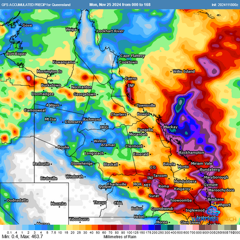
GFS & EC Accumulated Rainfall For the Next 7 Days. Source: MetCentre
Wetter Days Ahead
After weeks of hot weather and severe storms, a slow-moving high is set to settle in the Tasman Sea. This system will drive onshore easterly winds across the region, combining with a broad, slow-moving upper trough and a cold pool of air. The result? Several days of rain and showers.
EC 500mb temperatures and surface winds. Onshore winds will push moisture into a cool upper atmosphere with a broad upper trough / cold pool of air located over the region. Source: MetCentre
The wet weather will initially favour Southeast Queensland and Northeastern NSW on Tuesday and Wednesday with falls of 60-80mm likely, but it’s expected to extend further up the coastline as the week progresses. A developing trough or low off the coast could enhance rainfall by increasing moisture and triggering additional showers and this has the potential to bring some heavy falls and will be monitored.
Adding to the mix is a decaying rainband associated with a slow-moving storm system from central Australia, which has been fueled by moisture from the weak negative Indian Ocean Dipole (IOD).

Satellite image showing extensive cloud, showers and storms across inland Queensland. Source: MetCentre
Cooler Temperatures on the Horizon
It’s not just the rain that will stand out—expect cooler-than-average temperatures across much of the state.
Brisbane CBD: Forecast to reach just 22°C on Wednesday, which is 6°C below the November average.
Toowoomba: Likely to struggle into the high teens, with a forecast maximum of 17–18°C, more than 8°C below average.
Central Queensland: Locations like Emerald and Biloela will only reach the mid-to-high 20s, 5–6°C below the November average for areas that typically push into the 30s this time of year.
The Tropics: Only northern regions, such as Townsville and Cairns, are expected to escape the cool spell, hovering around the low 30s for the remainder of the week.

GFS 850mb temperature anomalies on Wednesday showing cooler air over the state. Source: MetCentre
What to Expect
The combination of cloud cover, onshore winds, and rainfall will bring a welcome break from the heat, particularly for southern and central Queensland. However recent shower and storm activity has wet the catchments which could see some local renewed creek and river rises in the southeast, while some models push the potential for higher falls about parts of the central Queensland coastline.
Weatherwatch – your trusted partner in weather intelligence.


