October 16, 2024
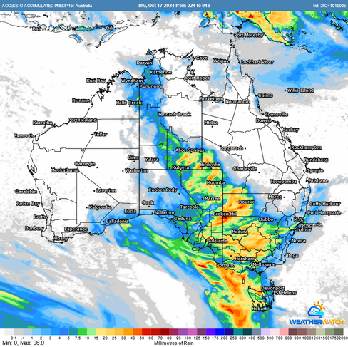
The next 2-3 days will see a cold front push a band of showers and storms across central to eastern Australia. Source: HailTracker
It’s been an active few days across Australia, with a devastating hailstorm hitting the town of Casterton, Victoria this afternoon, covering the ground with golf-ball-sized hail. However, all eyes are now on an approaching cold front currently tracking through Western Australia.
Thursday: Gales, Dry Lightning, and Bushfire Concerns in South Australia
Tomorrow (Thursday), this cold front will move into South Australia, bringing northwesterly gales capable of producing damaging wind gusts. To make conditions even more hazardous, instability may trigger storms that generate dry lightning—lightning that occurs with little or no rainfall. The combination of strong winds, temperatures in the low 40s, and lightning risks will result in elevated bushfire conditions, with high to extreme fire danger forecasted across the state.
Strong winds will push across South Australia on Thursday and combine with temperatures pushing well into the 40s to bring extreme bushfire dangers to parts of the state. Source: MetCentre.
Additionally, the dry conditions in the atmosphere will make it conducive to microburst activity, which could result in severe storms producing further damaging wind risks.

Forecast soundings show strong wind shear with high bases and low levels of surface humidity. This is very conducive to microbursts in thunderstorms. Source: MetCentre.
Friday: Storms and Gales for Southeastern Australia
On Friday, this front will push into Victoria and parts of NSW, bringing gales and further storm activity. Inland NSW and northern Victoria will be at risk for storms, with the potential for damaging winds and large hail. However, the presence of morning cloud or earlier storm activity may limit the severity of storm development in some areas - but aside from this, there is the potential for a more traditional severe thunderstorm setup.
Forecast rainfall for Thursday and Friday comparison. Source: MetCentre.

Forecast soundings in NSW are more traditionally conducive to severe storms with surface based instability and very strong wind shear. However, a weak cap may result in early initiation or remnant cloud cover which is providing some uncertainty.. Source: MetCentre.
Saturday: Storms Contracting to Southeastern Queensland.
By Saturday, the front will have swept away much of the moisture and instability across the continent, except for southeastern Queensland, where isolated showers and storms may persist.

Precipitable Water chart showing drier air pushing into the southern half of the country on Saturday and any moisture (and associated instability) contracting into Queensland and northern Australia. Source: MetCentre.
Weatherwatch – your trusted partner in weather intelligence.


