November 7, 2024
Summer has arrived with a vengeance across large parts of Queensland and northern NSW. Yesterday, Birdsville hit 45°C, with that intense heat spreading eastward today. Ipswich and western Brisbane sweltered at 37°C, with humidity making temperatures feel closer to 40 degrees in some areas!
Despite the heat and humidity, all but a lone storm cell developed on the ranges in Southeast Queensland this afternoon, though NSW saw more shower and storm activity. It raises the question: with so much heat and humidity, why aren’t we seeing storms like we did a few days ago? Further more, why did most of the storms occur in NSW?

Very isolated, weak storms occurred in Southeast Queensland today. Source: Weatherwatch Dashboard

Meanwhile extensive storms occurred across northeastern NSW with much more lightning. Source: Weatherwatch Dashboard
The Role of the Cap in Storm Development
The answer lies in a weather feature called a “cap”—a stable air layer 1-2km above the surface that stops air from rising. For thunderstorms to develop, air needs to rise; if the air is too stable just above the surface, the instability higher up can’t be accessed, resulting in limited storm activity.

ACCESS-G sounding for Southeast Queensland showing strong instability and a strong cap (stable zone). Source: MetCentre
Interestingly, the cap is essential for severe storm development. If the cap is too weak, storms can develop too early, leading to a cloudy, cluttered atmosphere where storms have to compete for energy. In other words, there’s a “Goldilocks zone” for the cap, where it’s strong enough to hold back storm formation until late in the day but weak enough to eventually break.
How NSW Saw Storms Despite the Cap
Today in NSW, a band of mid-level moisture moved across, producing high-based showers and storms above the cap. As this activity moved into more unstable coastal air, some storms tapped into this energy, intensifying over Cessnock and bringing damaging winds and large hail. This type of setup is a common way to overcome the cap.

ACCESS-G sounding for near Cessnock. This shows an unstable layer above the surface allowing for storms to develop in the mid-level instability. Source: MetCentre
The Forecast: A Challenging Week for Storm Prediction
It’s likely the cap will remain a complicating factor for the next 6-7 days, with plenty of instability present but making shower and storm activity increasingly tricky to forecast. This could be one of those weeks where storms are forecast each afternoon but don’t materialise as often.
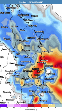
GFS Lifted Indices showing prevalent instability over the region for the next 8 days. Source: MetCentre
Elevated terrain, like mountain ranges, can help storms push through the cap, so we expect that a lot of the shower and storm activity across southeast Queensland and northeastern NSW will favour these higher areas initially. Early indications suggest the cap could weaken next week, increasing storm chances on some coastal plains—something we’ll be watching closely.
Given how dynamic these weather patterns are, it’s not unusual for forecasts to shift significantly from day to day. Sometimes a small change in the cap’s strength can mean the difference between a fine day or severe supercell storms!
Weatherwatch - Your Trusted Partner in Weather Intelligence


