
January 29, 2025


A small low near Cairns has already produced falls of 300mm during the last 24 hours. Source: MetCentre
A small tropical low near Cairns has made its presence felt, delivering the long-awaited wet season to north Queensland. In the past 24 hours, rainfall totals of 100-200mm have been recorded between Cairns and Cardwell, with some localised falls reaching 300mm. However, there’s potential for significantly more rain as this tropical low stalls. The situation may become more complex if the low evolves into a broader, multi-centred system, with another low potentially developing to the southeast and becoming dominant.
Multiple Steering Systems Causing Low to Stall
The tropical low is wedged between two weather systems. A broad upper trough across eastern Australia is maintaining a westerly push through the upper atmosphere, supported by a weak but present Jetstream arcing into northern Queensland. In contrast, a broad mid-level ridge across central Australia is delivering low-level easterly winds. These opposing wind directions are effectively anchoring the system in place, keeping the low slow-moving over the next few days. During this time, gusty easterly winds will continue to push moisture-laden air across the northeastern Queensland coastline, dumping potentially hundreds of millimetres of rainfall.


An upper trough (300mb temp & wind barbs) is bringing increasing westerly wind shear through the upper atmosphere, while a broad mid-level ridge (700mb temp & wind barbs) due to hot conditions across western to central Australia is exerting easterly winds resulting in the system remaining slow moving. Source: MetCentre
Potential for a Westward Nudge (towards the coastline) on the Weekend
By the weekend, a high-pressure system is expected to push into the Tasman Sea while the upper trough (and associated weak Jetstream) weakens. This could result in the low shifting westward, potentially crossing the coastline. Whether the system crosses as a tropical low or intensifies into a tropical cyclone remains uncertain, but either scenario brings the risk of torrential rainfall. Rainfall totals in excess of 1000mm (a full metre of rain!) are plausible over the duration of the event in some areas.

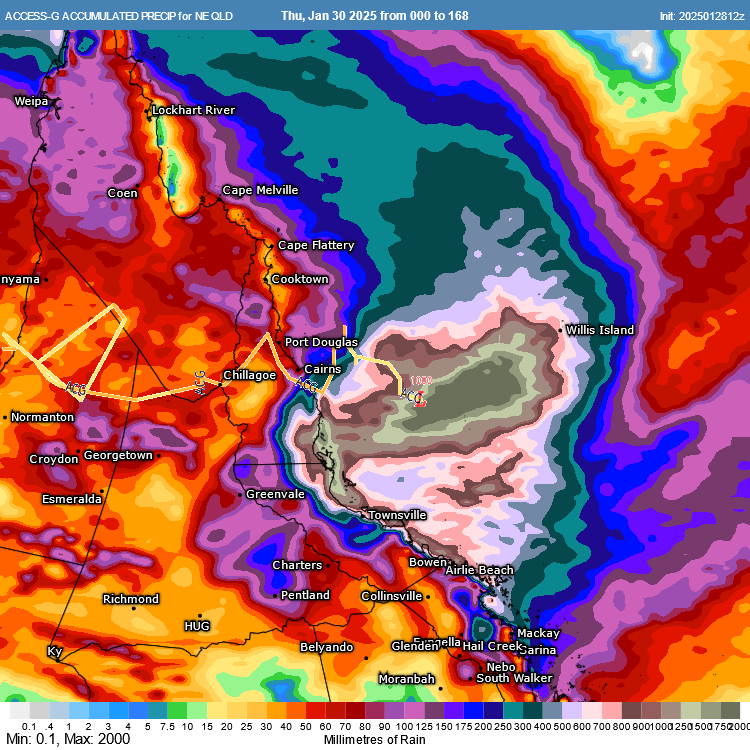

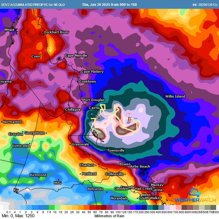

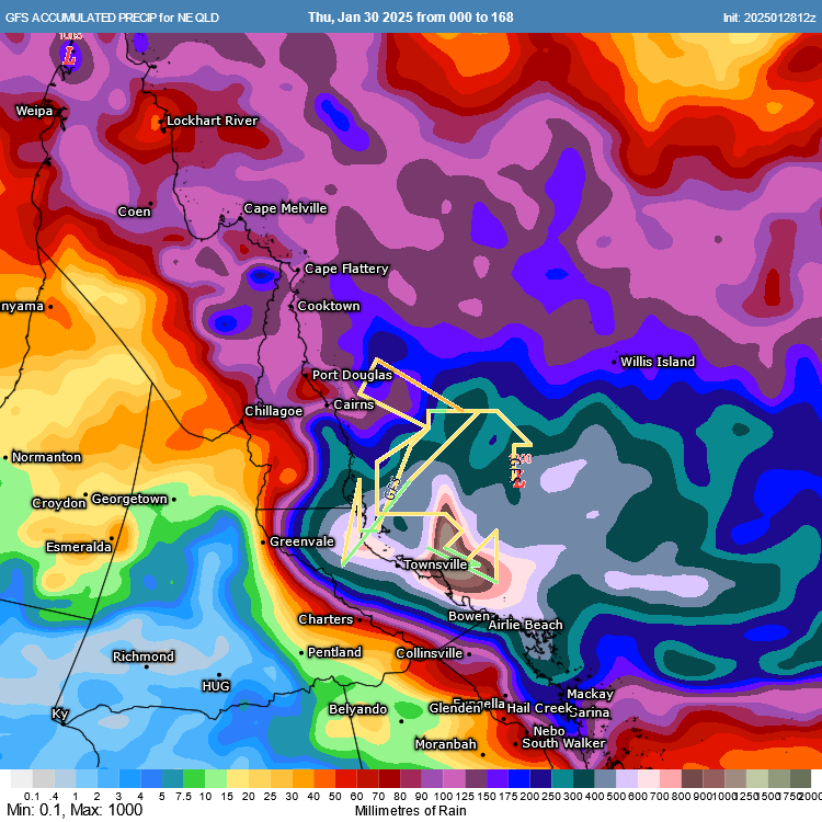
ACCESS, EC and GFS next 7-day forecast rainfall and their respective forecasts of the passage and development of a low. Source: MetCentre
Tropical Cyclone Potential Remains Complex
Most guidance suggests parts of the low may reach tropical cyclone strength but there is increasing uncertainty as to whether it will become organised enough. The longer the system remains out to sea, the higher the chance of the system developing into a tropical cyclone.
Some models suggest the Coral Sea low could steer moisture and convergence into the Gulf of Carpentaria, increasing the tropical cyclone potential there. Others indicate the two systems could interact, further complicating the forecast. Meanwhile, additional lows in the eastern Indian Ocean and near the Pacific Islands are also being monitored for tropical cyclone development and conditions overall still remain conducive to tropical cyclone develop around northern Australia.

EC wind gusts (knots) showing multiple potential tropical cyclone systems by next week. Source: MetCentre
With the wet season now in full swing, remember safety first when it comes to flooding. Avoid swimming in flood waters, and never drive through flooded roads. Residents should also consider what preparations they need to undertake in case they become isolated.
Weatherwatch – your trusted partner in weather intelligence