Severe Storms to Continue Across Eastern Australia
- Weatherwatch
- Jan 12
- 3 min read
January 12, 2025
ACCESS G CAPE indicating that moderate to strong levels of instability will continue across eastern Australia during the next 4-5 days. Source: MetCentre
It's already been an active few days across eastern Australia, and while severe storms have been isolated, they’ve certainly left their mark. Yesterday, Charters Towers was hit by a severe storm, with WeatherIQ capturing dramatic footage of a roof being ripped off a shed as the violent storm swept through the town.
While no official warnings were in place by the Bureau of Meteorology, Weatherwatch's own system that intelligently uses advanced 3D radar tracking technology to determine the intensity of storms provided the town with nearly 30 minutes warning of the severe storm's impact.

Weatherwatch's alerting system providing real-time warnings updated every five minutes (purple box indicates warning zones). Source: HailTracker
More Severe Storms Expected
Severe storms are set to continue this week as a broad long-wave upper trough remains parked across eastern Australia. This is bringing cool air in the upper atmosphere, which, when combined with the humid E to NE winds from the Pacific Ocean, is generating widespread instability and resulting in shower and storm development.

500mb temperatures and wind shear showing the broad region of cooler air across eastern Australia. However wind shear is a little stronger over Victoria and central to northern Queensland. Source: MetCentre
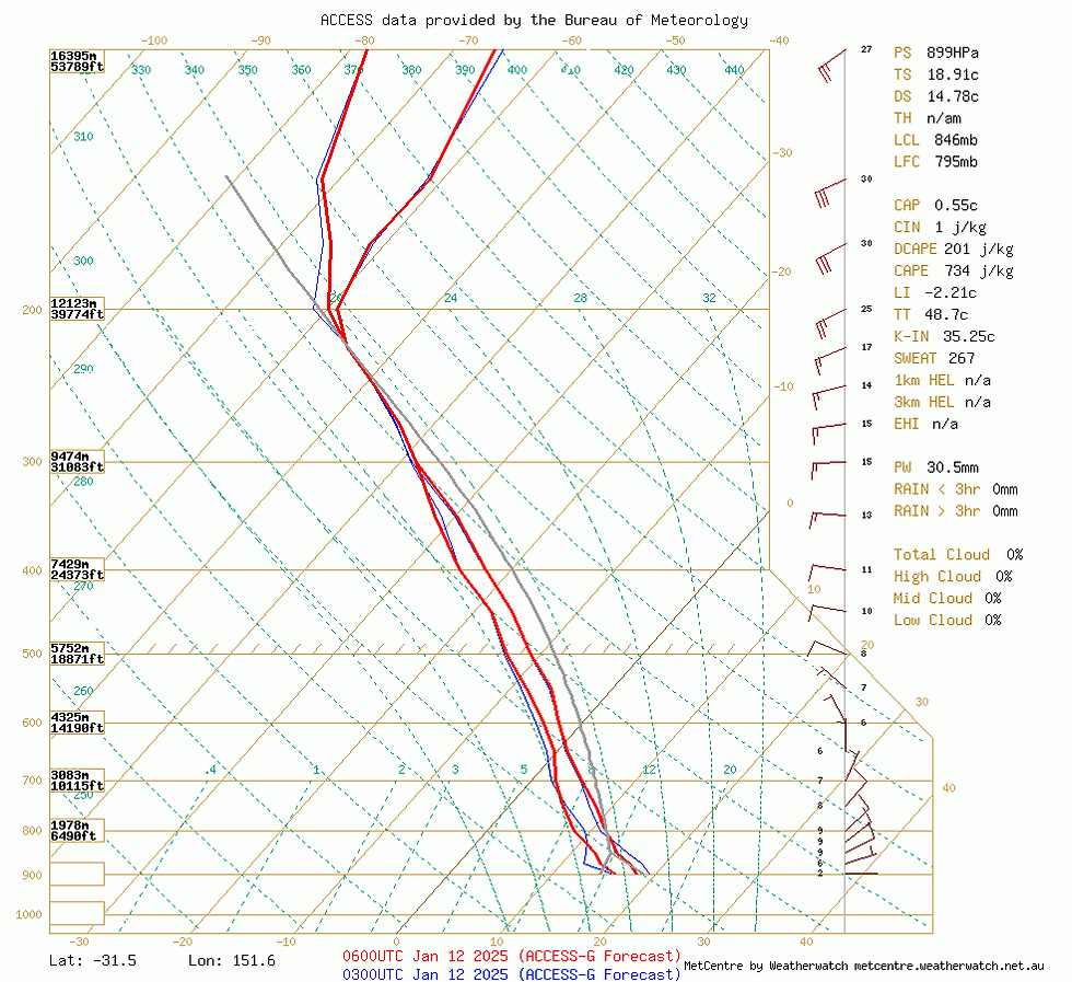
Today, storms are likely to develop across eastern Australia, from the tip of Cape York to Tasmania. Fortunately, the spread of severe storms will be limited due to weak wind shear in the upper atmosphere. Wind shear supports the development and longevity of severe storms; in its absence, storms struggle to sustain over long distances, often becoming "pulse-severe." These storms bring brief bursts of severe activity over small areas, making them less likely to impact specific locations than long-lived severe storms.

ACCESS sounding for NSW showing weak levels of wind shear (5-10 knots throughout the upper atmosphere) that's not conducive to traditional severe storm activity. Source: MetCentre
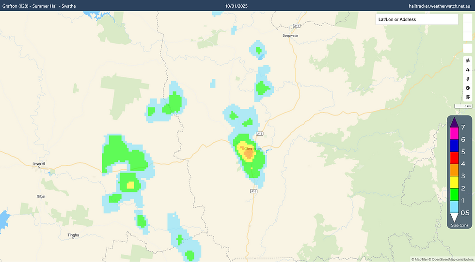
An excellent example of this was the Glen Innes hailstorm on Friday, which pulsed into a severe phase as it tracked into town.

2-4cm hail was identified over the Glen Innes region - the storm unfortunately timing its severe pulse right over the town. Source: HailTracker
Despite the weaker wind shear, slow-moving storms can still produce heavy rainfall and flash flooding, particularly across parts of eastern NSW and southeastern Queensland. Meanwhile, a short-wave upper trough in Victoria may increase instability and wind shear, heightening the threat of damaging winds and hail across central to eastern areas of the state. In Queensland, very strong instability across central eastern to northeastern regions, combined with unusually strong westerly wind shear and cold upper temperatures, makes these areas prime for severe storm development once again.
Soundings for Victoria and central to northern Queensland are more conducive to severe storm development due to the stronger levels of instability and wind shear present. Source: MetCentre
Midweek Outlook
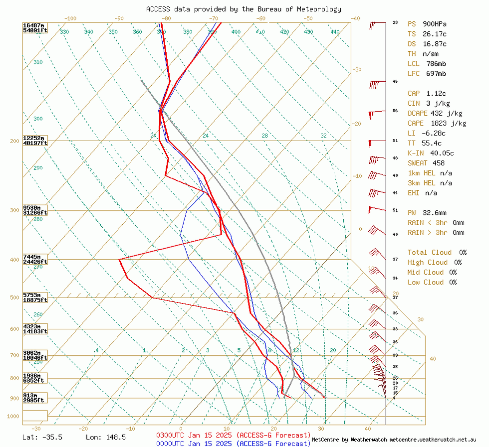
The pattern of showers and storms across eastern Australia will persist into Monday and Tuesday. By Wednesday, a stronger upper system and associated cold front could increase the potential for severe storms across parts of Victoria and inland NSW. This setup may resemble a more classic severe thunderstorm environment, with wind shear no longer acting as a limiting factor due to the sharpness of the approaching upper system.

Forecast soundings for southern NSW are currently supportive for much more significant severe storm activity on Wednesday. Source: MetCentre
By Thursday, this same system could push into NE NSW and SE QLD, provided that drier westerly winds do not approach too close to the coastline.
The cold front may sweep the current humid, unstable air out to sea, offering a reprieve from the wet and stormy conditions currently affecting the region. However, long-range trends for January remain preliminary and subject to change.
Accumulated forecast rainfall during the next 7 days across eastern Australia from EC and ACCESS. Source: MetCentre
Tropics May Finally Awaken during the Second Half of January

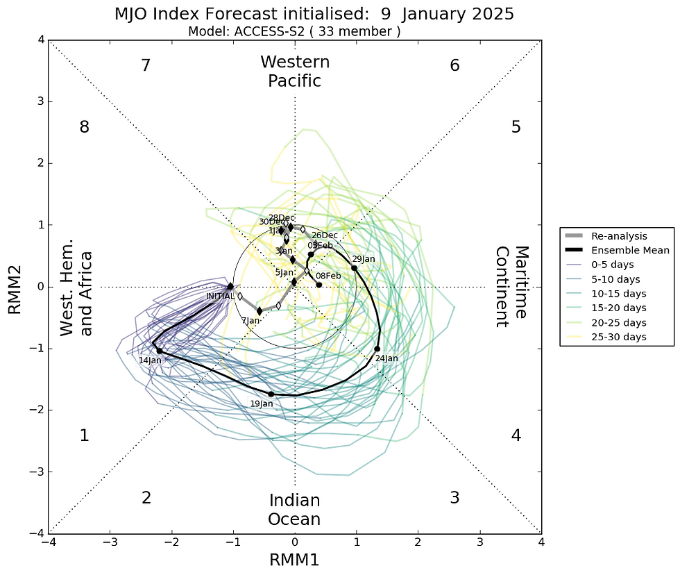
MJO is forecast to move into a more favourable phase for tropical rainfall and tropical cyclone development from the following weekend. Source: BoM.
Looking into late this week and the following week, the Madden-Julian Oscillation (MJO) is expected to move into phase across northern Australia. This stronger burst of westerly winds could increase tropical activity across far northern Australia. These patterns are also more conducive to tropical cyclone development. While some models suggest potential tropical cyclone development off the northwestern West Australian coastline, inconsistencies in forecasts mean the only conclusion for now is an increased potential for tropical cyclone activity.
Weatherwatch – your trusted partner in weather intelligence.


