

January 24, 2025
Just one week after giant hail and supercells swept through parts of NE NSW and SE QLD, severe storms returned to the region—this time with even more widespread impacts.
By mid-morning, Byron Bay experienced 106km/h winds, while large sections of the Gold Coast were lashed by 93km/h gusts as a band of severe storms tore through. In the afternoon, golfball hail pummelled Armidale, and Glen Innes endured its second severe hailstorm in two weeks. Meanwhile, the Darling Downs made headlines with a confirmed tornado near Kaimkillenbun, close to Dalby.
The setup shared some uncanny similarities between last week's setup that produced giant hail to parts of Grafton and the Gold Coast Hinterland - that was a southeast change.
The Role of the Southeast Change
One critical feature that tied these storm events together was the southeast change. In both setups, morning storm activity played a key role by generating a strong outflow boundary that amplified low-level winds.
Australia frequently experiences severe storms, with some regions among the highest annual frequencies in the world. Yet, Australian storms often lack one key ingredient found in places like the United States: strong winds at the surface.
This absence can cause storms to weaken when their cool outflow races ahead of the system, cutting off access to the warm, unstable air they rely on. However, in these setups, the southeast change—and the outflow boundary from earlier storms—created opposing surface winds that stopped storms from becoming "outflow dominated."

Additionally, the opposing wind directions in the lower atmosphere generated helicity (spin), encouraging the formation of the rotating updrafts that define supercells.


3D radar of the Kaimkillenbun supercell that produced a tornado. Note the "notch" in the 3D scan, this a Bounded Weak Echo Region within the storm caused by the mesocyclone (rotating updraft). Source: Weatherwatch MetCentre
Modified Southeast Winds: A Complex Factor
The southeast change doesn’t always result in storms directly along the boundary. Instead, some of the most severe storms form behind the southeast change. These winds often modify as they track inland, gaining heat and curving back to the northeast while retaining their moist, origins. While the northeasterly winds can have higher levels of surface humidity - this is often shallow. Southeast winds have "deeper" moisture (often more than a kilometre thick in the lower atmosphere).

This was evident in Dalby, where at 2pm, it was 38°C with a dew point of 17°C (28% humidity), accompanied by NNW winds gusting to 41km/h. By just after 3pm, it was 30°C, with a dew point of 23°C (65% humidity), and easterly winds gusting to 63km/h. Similarly, in nearby Oakey, ENE winds gusted between 45–55km/h for much of the day.


Sounding before and after the boundary of the modified change pushed through Dalby. Even though it was cooler after the change, it was actually more unstable in the more humid airmass. Further, the higher humidity levels make conditions more favourable for tornado development. Source: Weatherwatch MetCentre
Armidale followed suit: at 3pm, it recorded 26°C with a dew point of 18°C, and ENE winds gusting close to 40km/h.
Surface winds alone don’t create severe storms. A nearby upper trough provided the necessary cold air, strong instability, and enhanced wind shear higher in the atmosphere. These opposing winds aloft, combined with strong surface winds, set the stage for widespread severe storm activity. Fortunately once again Weatherwatch's SmartHail alerting system jumped into action - issuing timely hail warnings to protect cars and assets.

Weatherwatch's SmartHail warning system issuing realtime alerts yesterday.
Models vs. Meteorologists
Interestingly, forecast models struggled to predict the extent of this outbreak, with some showing little to no activity. However, satellite imagery and meteorological expertise identified the conditions for a significant storm day, underscoring the vital role of meteorologists over automated forecasting tools.


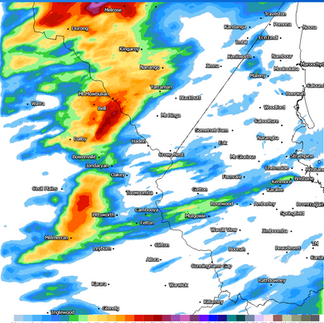
Activity developed rapidly along the boundary of the change, fueled by strong and gusty easterly winds feeding humid air into the storms. Source: Weatherwatch MetCentre


Comparison between forecast models and what actually happened using rainfall data from the Virtual Rain Gauge network.
More Storms Today & Tomorrow
More storms are expected today but the main focus will shift northwards in response to hot, dry westerly winds pushing closer to the coastline. There is the risk of storms along the Southeast Coast, but the chance is quite low - there's a higher concern further north, particularly around the Wide Bay & Burnett, Central Highlands & Coalfields and also the Capricornia areas before the threat shifts more into central Queensland by tomorrow. While severe storms are expected today, the overall intensity of storms on average should be less than yesterday's activity.


Comparison between CAPE yesterday and today showing the drier air diluting instability in southeastern Queensland which may keep most of the storms further north. Another SE change will track into NE NSW, though a very strong cap here will mean storms may struggle to develop. Source: Weatherwatch MetCentre
With the severe weather season still in full swing, Weatherwatch's expert meteorologists and SmartHail™ system remain on standby to help businesses and residents stay ahead of the storms.
Weatherwatch – your trusted partner in weather intelligence.