October 30, 2024
The east Australian storm season has strongly favoured Southeast Queensland and Northeastern NSW so far, and that trend looks set to continue. Today saw an isolated severe storm manage to overcome a strong atmospheric cap northwest of Brisbane, producing large hail and likely damaging winds. For much of the region, however, conditions stayed clear.

Today (Wednesday) saw a single, lone severe storm briefly overcome the strong cap to become severe to the northwest of Brisbane. HailTracker and StormPredict overlaid. Source: MetCentre
Thursday: Increasing Storm Potential
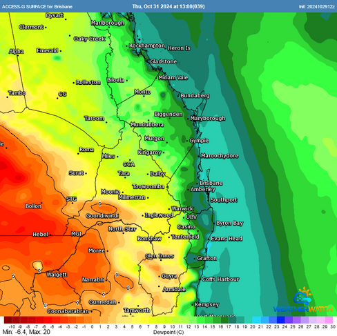
Tomorrow (Thursday), storm activity is expected to expand as another upper trough moves in, bringing cold air to the upper atmosphere—a key ingredient for thunderstorms. Initially, storm cells were expected to have been very isolated, but recent forecast models support increasingly higher level of moisture in the region. This boost in moisture ups the odds of thunderstorm activity over Southeast Queensland and Northeastern NSW.
ACCESS surface dew points for Thursday afternoon (12z vs 00z run). It's subtle - but moisture is edging a little further inland which is increasing the chance of storm activity. Source: MetCentre
Thankfully, storms should stay isolated, though instead of just one or two cells, we may see a few in the region. With supportive wind shear and cold air in the upper atmosphere (around -15°C at 500mb), a couple of these storms are likely to become severe, with large hail being the primary threat. However, this setup isn’t expected to produce storms as intense as the Halloween outbreak in 2020, which saw suburbs extensively impacted by giant hail.
ACCESS CAPE & Forecast Sounding for Thursday showing hefty levels of instability, though slightly weaker wind shear could see the worst storms avoid the Brisbane metropolitan area. Source: MetCentre
Nonetheless - it's not safe to Trick of Treat if there's storms nearby due to lightning so ensure you're close to shelter should storms occur (this may particularly be the case for inland areas of Southeast Queensland, up into the Sunshine Coast and Wide Bay & Burnett and then possibly around areas of the Northern Rivers of NSW).
Friday: Potentially Higher Storm Risk
The potential for thunderstorms will rise further on Friday as a southeast change approaches. With CAPE (Convective Available Potential Energy) of around 1500-2000 j/kg and bulk shear reaching 35-40 knots, conditions look ideal for severe storm development. Large hail is a likely threat once again, and given the supportive conditions, there’s a preliminary risk of one or two supercells that could bring giant hail. However, the timing of the southeast change could impact the storm threat—if it arrives earlier than expected, the risk of storms (and associated severe weather) will decrease.
ACCESS CAPE & Forecast Sounding for Friday showing strong levels of instability. Of note is the southeast change that can provide additional convergence and low level wind shear for storms and storms are more likely to impact Brisbane on Friday than Thursday at this stage. Source: MetCentre
Friday is the day of higher concern, as storms will likely be more scattered, increasing the odds of impacts across the region and we definitely recommend paying attention to the radar and any warnings issued.
Saturday: Calmer Conditions Expected
By Saturday, a weak ridge will push southeast winds through the region, contracting any significant storm activity away from Southeast Queensland though some embedded storms will remain possible.

Combined ACCESS CAPE & Wind Barb Forecast for Saturday. Onshore southeast winds may contract the strongest storms into less populated areas of Queensland. Source: MetCentre
Be Prepared for Possible Severe Weather
Historically, the month of November is the climatological peak of the thunderstorm season. Now's the time to finalise your preparations for your emergency kit to ensure you're prepared!
Weatherwatch – your trusted partner in weather intelligence.


