November 10, 2024
The storm season is set to kick up a gear over the coming days as a warm and humid airmass blankets the southeastern quarter of Queensland and northeastern quarter of NSW, bringing areas of instability. Severe storms are likely, although they should remain isolated but more people are likely to be impacted by storms than in some of the recent setups.

Satellite imagery showing an unstable airmass over the Darling Downs this morning. Source: MetCentre
Dual Sources of Moisture
Moisture is streaming in from two sources: firstly, from the Coral Sea, which has contributed to the muggy November conditions. Secondly, a weak negative Indian Ocean Dipole (IOD) has led to increased shower and storm activity across central Australia. This moisture is drifting east and is likely to supply additional moisture to the region over the coming days.

Elevated levels of precipitable water may bring flash flooding over the coming days (along with slow moving storms). Source: MetCentre
Flash Flooding Potential Due to Slower-Moving Storms, Higher Precipitable Water
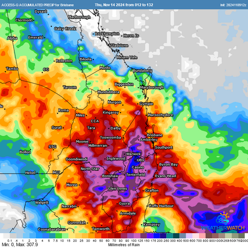
Unlike previous setups where the primary concern was large hail and damaging winds, the combination of moderate wind shear and higher moisture levels in the atmosphere brings a new threat—flash flooding. The storms are expected to move more slowly, with an increase in precipitable water, raising the risk of heavy, prolonged rainfall in some areas. Expect more areas to be impacted by lightning too with a broader threat of storm activity.
Forecast rainfall for the next 5 days from GFS, ACCESS-G, EC and BoM. Source: MetCentre
Additionally, while earlier storms have mostly stayed coastal, this setup may extend further inland. Although it won’t reach the far outback of NSW and Queensland, more inland areas should see rain, showers, and storms. This will be welcome news for farmers, as eastern Australia has experienced a dry start to the season, with rainfall mainly confined to coastal areas.

Rainfall anomalies for August - October, note in eastern Australia large parts of inland areas have had below average rainfall. A more westward progression of rainfall will be welcomed by farmers. Source: BoM
Stormy Days Ahead
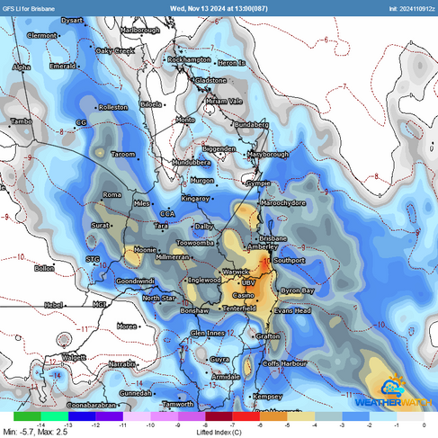
The next five days will see an active storm pattern, particularly today (Sunday) and tomorrow, with a brief break on Tuesday. Another trough is expected on Wednesday and Thursday, bringing stronger but more isolated storms as wind shear increases. Today and tomorrow, however, are likely to feature more widespread rain, showers, and scattered storms with a lower potential for severe activity. Late this week, a ridge is likely to build along the coastline which should see storms ease and contract further inland.
Forecast Lifted Index for the next 6 days showing plenty of instability across the region. Source: MetCentre
With November and December being the climatological peak of storm season in eastern Australia, this November is already shaping up to be more active than usual. It’s a timely reminder of the importance of staying prepared for severe weather events—including the old but very important phrase, "If it's flooded, forget it"

C3 forecast loop for today across Southeast Queensland. Source: MetCentre
Weatherwatch – your trusted partner in weather intelligence.


